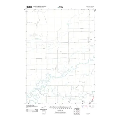
2010 Map of Parker
USGS Topo · Published 2010About this map
Henrys Fork and the Teton River converge in this corner of the Snake River Plain, defining a landscape shaped by intricate water management. The terrain is dominated by the Egin Bench, where an extensive network of irrigation infrastructure supports the local agricultural economy. Features like the Consolidated Farmers Canal, Saint Anthony Canal, and Independent Canal weave between the small settlements of Parker, Heman, and Egin. The convergence of these waterways, including the winding Warm Slough, illustrates the vital role of the rivers in sustaining these Idaho communities. To the south, the grid transitions into the residential and agricultural outskirts of Salem and Sugar City, while the northern reaches include Davis Lake and the Egin Lakes, highlighting the area's natural wetlands amidst the cultivated fields.
Find a feature on this map
50 named features on this map. Tap any name to fly to it.
Don’t see what you’re looking for? This feature index may not catch every label — zoom into the map to look around manually.
Map Details
Editions of this 2010 Parker Map
This is the sole edition of this map. No revisions or reprints were ever made.
Other maps of this area

1948 · Parker
USGS Topo · 1:24,000

1949 · Rexburg
USGS Topo · 1:24,000

1950 · Parker
USGS Topo · 1:24,000

1950 · Rexburg
USGS Topo · 1:24,000

1950 · St Anthony
USGS Topo · 1:24,000

1951 · Moody
USGS Topo · 1:24,000
1951 · Menan Buttes
USGS Topo · 1:24,000

1951 · Plano
USGS Topo · 1:24,000

1955 · Ashton
USGS Topo · 1:250,000

1955 · Driggs
USGS Topo · 1:250,000