
1951 Map of Moody
USGS Topo · Published 1952About this map
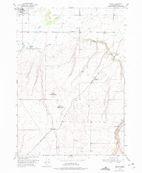
The agricultural landscape of Madison County unfolds across this 1951 survey, centered on the irrigation networks and rail lines that sustained the Snake River Plain. In the northwest corner, Sugar City serves as a primary hub, adjacent to the Sugar City Cemetery. The terrain transitions from the river bottomlands of the Teton River into the rising eastern highlands, punctuated by prominent landmarks such as Sommers Butte and Webster Butte. The Union Pacific railroad cuts a diagonal path through the territory, passing the small settlement at Parkinson and the distinctive Woods Crossing over Moody Creek. Local educational and civic life is anchored by the Moody Sch, while a complex system of waterways, including the Enterprise Canal, illustrates the intensive water management required for farming this Idaho volcanic soil during the mid-twentieth century.
Find a feature on this map
2 named features on this map. Tap any name to fly to it.
Don’t see what you’re looking for? This feature index may not catch every label — zoom into the map to look around manually.
Map Details
Editions of this 1951 Moody Map
2 editions found
Other maps of this area

1948 · Parker
USGS Topo · 1:24,000

1949 · Rexburg
USGS Topo · 1:24,000

1949 · Newdale
USGS Topo · 1:24,000

1950 · Ririe
USGS Topo · 1:24,000

1950 · Parker
USGS Topo · 1:24,000

1950 · Rexburg
USGS Topo · 1:24,000

1950 · Newdale
USGS Topo · 1:24,000

1950 · St Anthony
USGS Topo · 1:24,000

1950 · Rigby
USGS Topo · 1:62,500

1951 · Hawley Gulch
USGS Topo · 1:24,000