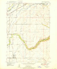
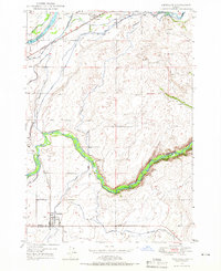
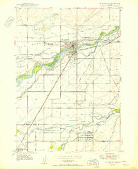
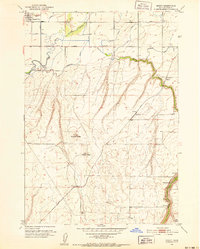
1950 Map of Newdale
USGS Topo · Published 1950About this map
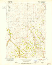
The Union Pacific railroad and the Union Pacific Highway serve as the primary conduits for commerce and travel through this corner of Fremont and Madison counties during the mid-twentieth century. The landscape is defined by an intricate network of irrigation, where the Henrys Fork and Fall River feed numerous man-made waterways. Prominent engineering features include the Crosscut Canal, the Enterprise Canal, and various water-control structures such as a Siphon, Flume, and Gaging Sta along the Teton River. These canals supported the agricultural development of settlements like Newdale and Chester. Genealogists may find interest in the Chester Cem located north of the Fall River. The map illustrates a highly managed hydrological system designed to transform the High Desert terrain into productive farmland, with the deep incision of Hog Hollow marking the natural topography east of the irrigated plains.
Find a feature on this map
26 named features on this map. Tap any name to fly to it.
Don’t see what you’re looking for? This feature index may not catch every label — zoom into the map to look around manually.
Map Details
Editions of this 1950 Newdale Map
This is the sole edition of this map. No revisions or reprints were ever made.
Other maps of this area
1949 · Newdale
USGS Topo · 1:24,000
1950 · St Anthony
USGS Topo · 1:24,000
1951 · Moody
USGS Topo · 1:24,000
1951 · White Owl Butte
USGS Topo · 1:24,000

1955 · Ashton
USGS Topo · 1:250,000

1955 · Driggs
USGS Topo · 1:250,000

1958 · Driggs
USGS Topo · 1:250,000

1958 · Ashton
USGS Topo · 1:250,000

1960 · Ashton
USGS Topo · 1:250,000

1962 · Driggs
USGS Topo · 1:250,000