
1949 Map of Newdale
USGS Topo · Published 1966About this map
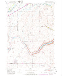
Henrys Fork and the Fall River dominate the northern landscape of this Idaho territory, creating a complex water management system for early agriculture. This late 1940s survey reveals a dense network of irrigation infrastructure including the Last Chance Canal, Union Canal, and Crosscut Canal. To the south, the Teton River carves a deep, winding path through the plateau, marking the boundary between Fremont and Madison counties. The settlements of Chester and Newdale serve as the primary hubs, linked by the Union Pacific Highway and the Union Pacific rail line. Local history is preserved in details like the Chester Cem and various unnamed windmills and farmsteads. The topographic record illustrates how the natural hydrology of the Snake River Plain was harnessed through engineering, with siphons and flumes crossing the varied terrain of Hog Hollow.
Find a feature on this map
23 named features on this map. Tap any name to fly to it.
Don’t see what you’re looking for? This feature index may not catch every label — zoom into the map to look around manually.
Map Details
Editions of this 1949 Newdale Map
2 editions found
Other maps of this area

1950 · Newdale
USGS Topo · 1:24,000

1950 · St Anthony
USGS Topo · 1:24,000

1951 · Moody
USGS Topo · 1:24,000

1951 · White Owl Butte
USGS Topo · 1:24,000

1955 · Ashton
USGS Topo · 1:250,000

1955 · Driggs
USGS Topo · 1:250,000

1958 · Driggs
USGS Topo · 1:250,000

1958 · Ashton
USGS Topo · 1:250,000

1960 · Ashton
USGS Topo · 1:250,000

1962 · Driggs
USGS Topo · 1:250,000