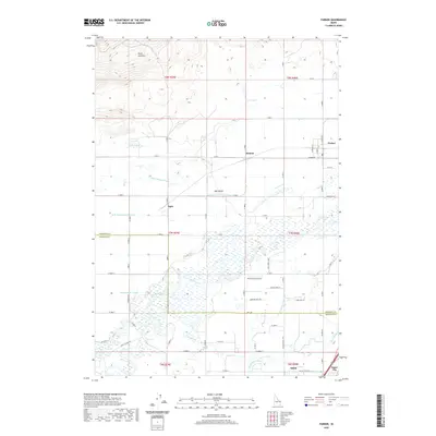
2020 Map of Parker
USGS Topo · Published 2020About this map
The agricultural landscape of the Egin Bench dominates this portion of the Snake River Plain, where an intricate network of irrigation systems supports the local farming economy. Small agrarian settlements including Heman, Egin, Salem, and the larger Parker and Sugar City are connected by a grid of rural roads and canals. The Teton River flows through the southern section of the quadrangle, fed by a complex system of waterways such as the Consolidated Farmers Canal and the Island Ward Canal. To the north, the terrain transitions toward the South Junipers, where the landscape becomes more varied with features like Davis Lake and the Egin Lakes. This map documents the essential relationship between water management and settlement patterns in eastern Idaho, showing how canals like the Saint Anthony Canal have historically shaped the development of these communities.
Find a feature on this map
49 named features on this map. Tap any name to fly to it.
Don’t see what you’re looking for? This feature index may not catch every label — zoom into the map to look around manually.
Map Details
Editions of this 2020 Parker Map
This is the sole edition of this map. No revisions or reprints were ever made.
Other maps of this area

1948 · Parker
USGS Topo · 1:24,000

1949 · Rexburg
USGS Topo · 1:24,000

1950 · Parker
USGS Topo · 1:24,000

1950 · Rexburg
USGS Topo · 1:24,000

1950 · St Anthony
USGS Topo · 1:24,000

1951 · Moody
USGS Topo · 1:24,000
1951 · Menan Buttes
USGS Topo · 1:24,000

1951 · Plano
USGS Topo · 1:24,000

1955 · Ashton
USGS Topo · 1:250,000

1955 · Driggs
USGS Topo · 1:250,000