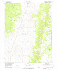
1969 Map of Parker Knoll
USGS Topo · Published 1972About this map
Otter Creek winds through the central corridor of Grass Valley in this late-1960s Piute County survey, revealing a landscape defined by sharp transitions between high plateaus and alluvial basins. The eastern half of the sheet is dominated by the massive rise of the Parker Mountain Awapa Plateau, where prominent heights like Parker Knoll and the Pine Peaks loom over smaller water bodies such as Dog Lake and Mud Lake. This topography creates a natural drainage system that feeds numerous canyons into the valley floor.
Find a feature on this map
18 named features on this map. Tap any name to fly to it.
Don’t see what you’re looking for? This feature index may not catch every label — zoom into the map to look around manually.
Map Details
Editions of this 1969 Parker Knoll Map
2 editions found
Other maps of this area

1885 · Beaver
USGS Topo · 1:250,000

1885 · Fish Lake
USGS Topo · 1:250,000

1896 · Fish Lake
USGS Topo · 1:250,000

1945 · Marysvale
USGS Topo · 1:62,500

1947 · Marysvale
USGS Topo · 1:62,500

1953 · Richfield
USGS Topo · 1:250,000

1956 · Salina
USGS Topo · 1:250,000

1958 · Richfield
USGS Topo · 1:250,000

1960 · Salina
USGS Topo · 1:250,000

1962 · Salina
USGS Topo · 1:250,000