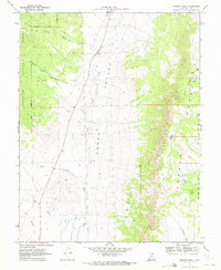
1969 Map of Parker Knoll
USGS Topo · Published 1972About this map
Grass Valley and the high elevations of the Awapa Plateau define the landscape of this Piute County survey. The terrain transitions from the alluvial floor of the valley, where Otter Creek meanders northward, to the steep, wooded slopes of Fishlake National Forest. This 1960s snapshot of the high desert shows a quiet, working land where a solitary Gravel Pit and a network of jeep trails provide the only infrastructure. High-altitude water sources like Dog Lake and Mud Lake sit atop the plateau, while numerous drainages such as Little Pole Canyon, Rock Canyon, and Andy Canyon cut through the western ridges. At 9,780 feet, the summit of Parker Knoll serves as the dominant landmark for this portion of the Awapa highlands, overlooking the southern reach of Forshea Draw.
Find a feature on this map
19 named features on this map. Tap any name to fly to it.
Don’t see what you’re looking for? This feature index may not catch every label — zoom into the map to look around manually.
Map Details
Editions of this 1969 Parker Knoll Map
2 editions found
Other maps of this area

1885 · Beaver
USGS Topo · 1:250,000

1885 · Fish Lake
USGS Topo · 1:250,000

1896 · Fish Lake
USGS Topo · 1:250,000

1945 · Marysvale
USGS Topo · 1:62,500

1947 · Marysvale
USGS Topo · 1:62,500

1953 · Richfield
USGS Topo · 1:250,000

1956 · Salina
USGS Topo · 1:250,000

1958 · Richfield
USGS Topo · 1:250,000

1960 · Salina
USGS Topo · 1:250,000

1962 · Salina
USGS Topo · 1:250,000