
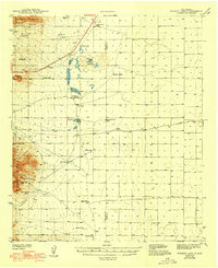
1943 Map of Parker Lake
USGS Topo · Published 1943About this map
Water management dominates this arid basin where the Tularosa Valley meets the San Andres Mountains. Surveyed by Max J. Gleissner and his team in the early 1940s, the map illustrates a network of essential desert resources, ranging from Alamo Spr and Texas Canyon Spr in the western highlands to man-made structures like Parker Lake and Drift Fence Well on the flats. The terrain transitions from the heights of Black Mountain and Antelope Hill down into the broad valley, where the county line separates Dona Ana and Otero.
Find a feature on this map
34 named features on this map. Tap any name to fly to it.
Don’t see what you’re looking for? This feature index may not catch every label — zoom into the map to look around manually.
Map Details
Editions of this 1943 Parker Lake Map
2 editions found
Other maps of this area

1891 · Las Cruces
USGS Topo · 1:125,000

1893 · Las Cruces
USGS Topo · 1:125,000

1916 · Tonuco
USGS Topo · 1:125,000

1916 · Point Of Sands
USGS Topo · 1:125,000

1932 · Tonuco
USGS Topo · 1:125,000

1940 · Orogrande
USGS Topo · 1:62,500

1940 · Newman
USGS Topo · 1:62,500

1941 · Desert
USGS Topo · 1:62,500

1941 · Organ Peak
USGS Topo · 1:62,500

1943 · La Mesa
USGS Topo · 1:62,500