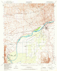
1949 Map of Parker
USGS Topo · Published 1966About this map
The Colorado River winds through this 1940s landscape, serving as the definitive border between California and Arizona while anchoring the life of the Colorado River Indian Reservation. Centered on the town of Parker, the map reveals a community structured around the Indian Agency and social institutions like the Mojave Indian Ch and Colorado River Day Sch. To the west, the Atchison Topeka and Santa Fe railroad crosses the Vidal Valley, connecting the settlement of Vidal to the river crossing near Earp.
Find a feature on this map
29 named features on this map. Tap any name to fly to it.
Don’t see what you’re looking for? This feature index may not catch every label — zoom into the map to look around manually.
Map Details
Editions of this 1949 Parker Map
2 editions found

Other maps of this area

1911 · Parker
USGS Topo · 1:125,000

1930 · Linskey
USGS Topo · 1:62,500

1931 · Moon Mtn
USGS Topo · 1:62,500

1932 · Moon Mtn
USGS Topo · 1:62,500

1942 · Blythe
USGS Topo · 1:250,000

1942 · MOON MTN
USGS Topo · 1:62,500

1943 · Giers Basin
USGS Topo · 1:62,500

1943 · Whipple Mts.
USGS Topo · 1:62,500

1943 · Parker
USGS Topo · 1:62,500

1943 · Vidal
USGS Topo · 1:62,500