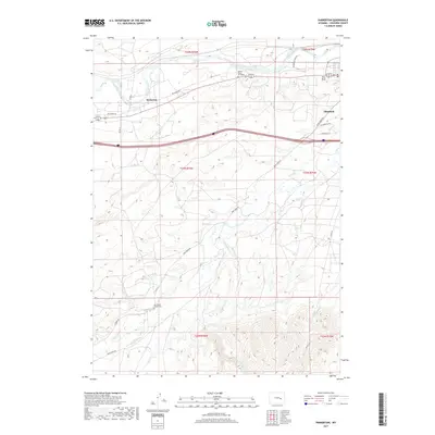
2017 Map of Parkerton
USGS Topo · Published 2017About this map
The North Platte River defines the northern edge of this Converse County landscape, where the settlement of Parkerton and the outskirts of Glenrock sit alongside the river's winding path. This 2017 study illustrates a region defined by high-plains topography and a network of named drainages including Deer Cr and Little Deer Cr. For those tracing local history or family lineage, the map identifies specific small-scale landmarks such as the Martin Ringo Gravesite near the river and the Mortimore Family Cem further south. The transportation corridor follows the valley, with Big Muddy Rd and Bluegrass River Rd connecting rural tracts. The terrain transitions from the river bottom into the dissected hills of the south, drained by Willow Cr and E Fork Little Deer Cr, showing a mix of established county roads and secondary routes like Continental Rd.
Find a feature on this map
28 named features on this map. Tap any name to fly to it.
Don’t see what you’re looking for? This feature index may not catch every label — zoom into the map to look around manually.
Map Details
Editions of this 2017 Parkerton Map
This is the sole edition of this map. No revisions or reprints were ever made.
Other maps of this area

1949 · Campbell Hill
USGS Topo · 1:24,000

1949 · Parkerton
USGS Topo · 1:24,000

1949 · Glenrock
USGS Topo · 1:24,000

1949 · Glenrock NW
USGS Topo · 1:24,000

1949 · Hylton Ranch
USGS Topo · 1:24,000

1950 · Campbell Hill
USGS Topo · 1:24,000

1950 · Lockett
USGS Topo · 1:24,000

1950 · Parkerton
USGS Topo · 1:24,000

1950 · Glenrock NW
USGS Topo · 1:24,000

1950 · Glenrock
USGS Topo · 1:24,000