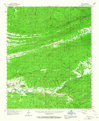
1960 Map of Parks
USGS Topo · Published 1968About this map
Parks lies at the convergence of the LA Fave River and Daly Creek, serving as a central point in this mid-century survey of the Ouachita National Forest. The landscape is dominated by a series of parallel ridges including Waldron Ridge and Dutch Creek Mountain, which dictate the flow of the Petit Jean River and the Poteau River. The distribution of rural landmarks like Keener Ch and Hawkins Cem illustrates the dispersed settlement patterns typical of the Arkansas river valleys before increased forest management consolidation. Fire observation points, such as the White Oak Lookout Tower and Abbot Lookout Tower, stand on prominent peaks, reflecting the vital role of forestry in the regional economy and land use during this era. Numerous family-named cemeteries and small community churches like Union Hill Ch provide essential data points for tracing genealogical roots in this terrain.
Find a feature on this map
122 named features on this map. Tap any name to fly to it.
Don’t see what you’re looking for? This feature index may not catch every label — zoom into the map to look around manually.
Map Details
Editions of this 1960 Parks Map
2 editions found
Other maps of this area

1879 · Poteau Mountain
USGS Topo · 1:62,500

1879 · Mountain Home
USGS Topo · 1:62,500

1887 · Poteau Mountain #1
USGS Topo · 1:62,500

1887 · Magazine Mountain #4
USGS Topo · 1:62,500

1887 · Mount Ida #2
USGS Topo · 1:62,500

1887 · Magazine Mountain #3
USGS Topo · 1:62,500

1887 · Magazine Mountain
USGS Topo · 1:62,500

1890 · Magazine Mountain
USGS Topo · 1:125,000

1890 · Mount Ida
USGS Topo · 1:125,000

1890 · Fort Smith
USGS Topo · 1:125,000