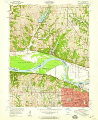
1948 Map of Parkville
USGS Topo · Published 1959About this map
The Missouri River carves a dramatic series of bends through the heart of this post-war landscape, defining the state line between Missouri and Kansas. On the northern bank, the historic community of Parkville centers around the campus of Park College, while the surrounding hills are dotted with rural schoolhouses like Stony Point School and Graden School. The river's serpentine path creates distinctive landforms such as Quindaro Bend and Pomeroy Bend, which historically influenced both railroad routing and early river navigation.
Find a feature on this map
76 named features on this map. Tap any name to fly to it.
Don’t see what you’re looking for? This feature index may not catch every label — zoom into the map to look around manually.
Map Details
Editions of this 1948 Parkville Map
This is the sole edition of this map. No revisions or reprints were ever made.
Other maps of this area

1890 · Kansas City
USGS Topo · 1:125,000

1894 · Kansas City
USGS Topo · 1:125,000

1910 · Leavenworth
USGS Topo · 1:62,500

1914 · Smithville
USGS Topo · 1:62,500

1934 · Bonner Springs
USGS Topo · 1:48,000

1934 · Shawnee
USGS Topo · 1:24,000

1934 · Edwardsville
USGS Topo · 1:24,000

1934 · Wolcott
USGS Topo · 1:24,000

1935 · Kansas City
USGS Topo · 1:24,000

1935 · North Kansas City
USGS Topo · 1:24,000