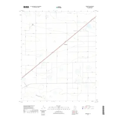
2019 Map of Parmerton
USGS Topo · Published 2019About this map
Parmerton sits at the heart of this Panhandle landscape, where the diagonal corridor of W 11th St and the adjacent Railroad Rd define the region's transport orientation. This area of Parmer County is characterized by a stark, systematic grid of agricultural roads, such as Co Rd 12 and Co Rd 15, which segment the terrain for industrial-scale farming. Water management is visibly critical here, with the ephemeral courses of Frio Draw, Catfish Draw, and Running Water Draw cutting across the survey area. These natural drainage features contrast with the rigid human-made infrastructure, including the Hefner Farms Airport in the northwest and the Memorial Park Cem further east. The map illustrates a contemporary rural Texas landscape where traditional ranching or farming footprints have integrated with modern aviation and long-distance transit routes.
Find a feature on this map
24 named features on this map. Tap any name to fly to it.
Don’t see what you’re looking for? This feature index may not catch every label — zoom into the map to look around manually.
Map Details
Editions of this 2019 Parmerton Map
This is the sole edition of this map. No revisions or reprints were ever made.
Other maps of this area

1954 · Clovis
USGS Topo · 1:250,000

1958 · Clovis
USGS Topo · 1:250,000

1963 · Clays Corner
USGS Topo · 1:24,000

1963 · Oklahoma Lane
USGS Topo · 1:24,000

1963 · Lariat NE
USGS Topo · 1:24,000

1965 · Bovina
USGS Topo · 1:24,000

1965 · Parmerton
USGS Topo · 1:24,000

1965 · Hub
USGS Topo · 1:24,000

1965 · Twin Lakes
USGS Topo · 1:24,000

1965 · Rhea
USGS Topo · 1:24,000