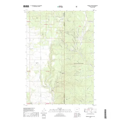
2017 Map of Parmlee Canyon
USGS Topo · Published 2017About this map
Black Hills National Forest land dominates this 2017 survey, where the rugged topography of the South Dakota-Wyoming border is defined by a complex network of canyons and high ridges. The map details the transition from the Bald Hills into the deeply incised drainages of Parmlee Canyon, Wet Parmlee Canyon, and Dry Parmlee Canyon. This terrain necessitated a specialized road network, visible in the numerous numbered forest routes such as South Parmlee BR 4G and the Bear Paw Loop. Evidence of the region’s ranching and homesteading history is preserved through scattered landmarks like Sanders Corral, Erman Well, and the Boyd Cem located near the western boundary. High points like Tysdal Ridge overlook a landscape dotted with essential water sources like Austin Spring and Slicker Dick Spring, which have long supported activity in this remote timber and grazing country.
Find a feature on this map
58 named features on this map. Tap any name to fly to it.
Don’t see what you’re looking for? This feature index may not catch every label — zoom into the map to look around manually.
Map Details
Editions of this 2017 Parmlee Canyon Map
This is the sole edition of this map. No revisions or reprints were ever made.
Other maps of this area

1894 · Deadwood
USGS Topo · 1:125,000

1896 · Harney Peak
USGS Topo · 1:125,000

1898 · Sundance
USGS Topo · 1:125,000

1899 · Newcastle
USGS Topo · 1:125,000

1901 · Harney Peak
USGS Topo · 1:125,000

1901 · Deadwood
USGS Topo · 1:125,000

1901 · Newcastle
USGS Topo · 1:125,000

1902 · Sundance
USGS Topo · 1:125,000

1916 · Deadwood
USGS Topo · 1:125,000

1953 · Rapid City
USGS Topo · 1:250,000