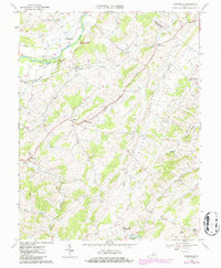
1967 Map of Parnassus
USGS Topo · Published 1986About this map
Natural Chimneys Regional Park serves as a prominent landmark in this portion of the Shenandoah Valley, where the North River meets the local topography near Mt Solon. The landscape is defined by the broad Glade Valley and the drainage systems of Mossy Creek and Moffett Creek. Evidence of earlier transportation networks remains visible through the Old Railroad Grade that winds past Castle Hill. Small crossroads settlements and agricultural hubs like Parnassus, Moscow, and Spring Hill are scattered throughout the quadrangle, often centered around local congregations such as St Pauls Ch and Emmanuel Ch. The presence of the North River Jr High Sch and various family-named features like Earhart and Towers illustrates the mid-century rural infrastructure of Augusta and Rockingham counties.
Find a feature on this map
33 named features on this map. Tap any name to fly to it.
Don’t see what you’re looking for? This feature index may not catch every label — zoom into the map to look around manually.
Map Details
Editions of this 1967 Parnassus Map
2 editions found
Other maps of this area

1892 · Harrisonburg
USGS Topo · 1:125,000

1894 · Staunton
USGS Topo · 1:125,000

1934 · Waynesboro
USGS Topo · 1:48,000

1939 · Waynesboro
USGS Topo · 1:62,500

1941 · Harrisonburg
USGS Topo · 1:62,500

1943 · Harrisonburg
USGS Topo · 1:62,500

1944 · Parnassus
USGS Topo · 1:62,500

1944 · Staunton
USGS Topo · 1:62,500

1947 · Staunton
USGS Topo · 1:62,500

1947 · Parnassus
USGS Topo · 1:62,500