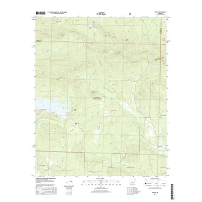
2017 Map of Paron
USGS Topo · Published 2017About this map
Ouachita National Forest dominates this landscape in central Arkansas, where the ridges and valleys of the eastern Ouachita Mountains meet the Saline River drainage. The small settlement of Reform and its associated Reform Point sit near the northern shores of Lake Winona, an area defined by a network of timber and forest service roads such as Reform Rd and Weyerhaeuser 24000 Rd. In the northeast, Lake Sylvia and its accompanying Wildlife Loop provide a recreational hub adjacent to the Ouachita National Recreation Trail, which traverses the high ground of Chinquapin Mtn and Wildcat Mtn. The hydrology is particularly complex here, with the Alum Fork Saline River and N Fork Saline River cutting through the terrain. To the east, the community of Paron serves as a local crossroads where Hwy 9 connects the river valleys. This 2017 survey details the contemporary balance of protected forest lands, managed timber tracts, and small rural outposts.
Find a feature on this map
64 named features on this map. Tap any name to fly to it.
Don’t see what you’re looking for? This feature index may not catch every label — zoom into the map to look around manually.
Map Details
Editions of this 2017 Paron Map
This is the sole edition of this map. No revisions or reprints were ever made.
Other maps of this area

1890 · Benton
USGS Topo · 1:125,000

1894 · Benton
USGS Topo · 1:125,000

1938 · Benton
USGS Topo · 1:48,000

1944 · Benton
USGS Topo · 1:62,500

1955 · Little Rock
USGS Topo · 1:250,000

1956 · Little Rock
USGS Topo · 1:250,000

1960 · Little Rock
USGS Topo · 1:250,000

1963 · Paron SW
USGS Topo · 1:24,000
1963 · Thornburg
USGS Topo · 1:24,000

1963 · Fourche SW
USGS Topo · 1:24,000