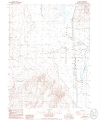
1986 Map of Parran
USGS Topo · Published 1986About this map
The Hot Springs Mountains and the West Humboldt Range frame this high-desert landscape in Churchill County, where industrial and natural history converge. The Southern Pacific railroad line cuts through the eastern terrain, serving the small settlement at Parran and providing a vital transit link across the Forty Mile Desert. Evidence of the region's mineral interests is found at the Mule Train Mine and various prospects scattered near the mountains, while the Hot Springs Relay Station indicates the area's role in communication and utility infrastructure.
Find a feature on this map
24 named features on this map. Tap any name to fly to it.
Don’t see what you’re looking for? This feature index may not catch every label — zoom into the map to look around manually.
Map Details
Editions of this 1986 Parran Map
2 editions found
Other maps of this area

1908 · Carson Sink
USGS Topo · 1:250,000

1910 · Carson Sink
USGS Topo · 1:250,000

1950 · Stillwater
USGS Topo · 1:62,500

1951 · Soda Lake
USGS Topo · 1:62,500

1951 · Carson Sink
USGS Topo · 1:62,500

1951 · Desert Peak
USGS Topo · 1:62,500

1957 · Reno
USGS Topo · 1:250,000

1959 · Reno
USGS Topo · 1:250,000

1960 · Reno
USGS Topo · 1:250,000

1979 · Carson Sink
USGS Topo · 1:100,000