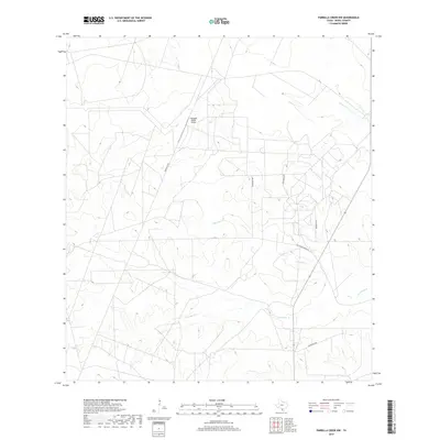
2019 Map of Parrilla Creek NW
USGS Topo · Published 2019About this map
The south Texas ranching landscape of Duval County is defined here by its network of private roads and seasonal drainages. Douglass Ranch Airport serves as a lone aviation landmark amidst the rolling terrain, situated near a series of unnamed ranch routes. The area is dissected by several named watercourses, including the south and north forks of Parrilla Creek, known on the map as Parrilla Cr S and Parrilla Cr N, as well as Animas Cr S in the northeast. Transportation is limited to a sparse grid of rural passages such as Los Lomas Ranch Rd and various iterations of Priv Ranch Rd, reflecting the large-tract land ownership typical of this region.
Find a feature on this map
7 named features on this map. Tap any name to fly to it.
Don’t see what you’re looking for? This feature index may not catch every label — zoom into the map to look around manually.
Map Details
Editions of this 2019 Parrilla Creek NW Map
This is the sole edition of this map. No revisions or reprints were ever made.
Other maps of this area

1956 · Freer
USGS Topo · 1:62,500

1956 · Las Mujeres
USGS Topo · 1:62,500

1956 · Laredo
USGS Topo · 1:250,000

1967 · Parrilla Creek SE
USGS Topo · 1:24,000

1968 · Parrilla Creek SW
USGS Topo · 1:24,000

1968 · Mills Bennett
USGS Topo · 1:24,000

1968 · Parrilla Creek NW
USGS Topo · 1:24,000

1968 · Parrilla Creek NE
USGS Topo · 1:24,000

1968 · San Pablo
USGS Topo · 1:24,000
1971 · Freer South
USGS Topo · 1:24,000