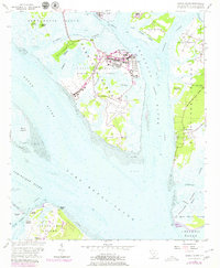
1956 Map of Parris Island
USGS Topo · Published 1979About this map
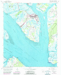
The Marine Recruit Depot dominates the central landscape of Parris Island, where extensive military infrastructure including the Parade Ground, a Yacht Basin, and the runways of Page Field contrast with the surrounding salt marshes and tidal creeks. This 1956 survey, updated through the late 1970s, captures the specialized geography of the US Naval Reservation alongside the residential and historical pockets of the Sea Islands. To the east on St. Helena Island, the presence of Fort Fremont and the Old Fort point to a long history of coastal defense overlooking the Beaufort River. The map reveals a delicate network of waterways like Archers Creek and Chowan Creek that separate islands such as Cat Island and Capers Island, while the southern reaches show the northern tip of Hilton Head Island near Dolphin Head and the Elliot Cem.
Find a feature on this map
65 named features on this map. Tap any name to fly to it.
Don’t see what you’re looking for? This feature index may not catch every label — zoom into the map to look around manually.
Map Details
Editions of this 1956 Parris Island Map
5 editions found
Other maps of this area

1920 · Okatie
USGS Topo · 1:62,500

1920 · Hilton Head
USGS Topo · 1:62,500

1920 · Bluffton
USGS Topo · 1:62,500

1942 · Okatie
USGS Topo · 1:62,500

1944 · Fort Fremont
USGS Topo · 1:62,500

1945 · Bluffton
USGS Topo · 1:62,500

1945 · Hilton Head
USGS Topo · 1:62,500

1947 · Savannah
USGS Topo · 1:250,000

1948 · Savannah
USGS Topo · 1:250,000

1956 · Frogmore
USGS Topo · 1:24,000