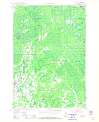
1950 Map of Parrish
USGS Topo · Published 1968About this map
Parrish and the surrounding timberlands of northern Wisconsin appear here in a transition between active industrial use and natural regrowth. The landscape is crisscrossed by an extensive network of Old Railroad Grade markings, revealing the historical reliance on rail for logging and transport. Cultural heritage is particularly evident through the names of local religious and educational centers, including the Estonian Ch and Lettish Ch in the southern portion of the quadrangle, suggesting the specific European immigrant communities that settled these townships. The abundance of namesake schools like Good Luck Sch, Liberty Bell Sch, and the Callsen Sch (Abandoned) provides a fine-grained look at the distributed rural population centers of the mid-20th century. High points like Lookout Mountain and the Basswood Lookout Tower overlook a terrain defined by the Prairie River and numerous lakes, from the large Enterprise Lake to the clusters of Apple Lakes.
Find a feature on this map
95 named features on this map. Tap any name to fly to it.
Don’t see what you’re looking for? This feature index may not catch every label — zoom into the map to look around manually.
Map Details
Editions of this 1950 Parrish Map
2 editions found

Other maps of this area

1899 · Wausau
USGS Topo · 1:125,000

1902 · Wausau
USGS Topo · 1:125,000

1939 · Cassian
USGS Topo · 1:48,000

1940 · Parrish
USGS Topo · 1:48,000

1940 · Monico
USGS Topo · 1:48,000

1940 · Rhinelander
USGS Topo · 1:48,000

1942 · Cassian
USGS Topo · 1:48,000

1942 · Elcho
USGS Topo · 1:48,000

1949 · Rhinelander
USGS Topo · 1:48,000

1950 · Monico
USGS Topo · 1:48,000