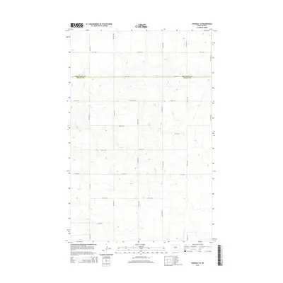
2014 Map of Parshall SE
USGS Topo · Published 2014About this map
The county boundary between Mountrail Co and Mclean Co serves as a central east-west axis for this North Dakota landscape, which is defined by a rigorous section-line road grid. The geography consists of upland terrain marked by the intersection of numerous rural thoroughfares, including 31st St NW in the north and 24th St NW at the southern edge. These roads, spaced in precise intervals, connect north-south corridors like 71st Ave NW and 66th Ave NW, illustrating the systematic land division used for agricultural settlement. This 2014 survey documents the enduring structure of the rural township system, where the landscape is organized by these numbered streets and avenues rather than concentrated urban centers.
Find a feature on this map
15 named features on this map. Tap any name to fly to it.
Don’t see what you’re looking for? This feature index may not catch every label — zoom into the map to look around manually.
Map Details
Editions of this 2014 Parshall SE Map
This is the sole edition of this map. No revisions or reprints were ever made.
Other maps of this area

1953 · Watford City
USGS Topo · 1:250,000

1954 · McClusky
USGS Topo · 1:250,000

1956 · Makoti SW
USGS Topo · 1:24,000

1956 · Blackwater Lake NW
USGS Topo · 1:24,000

1957 · Watford City
USGS Topo · 1:250,000

1958 · McClusky
USGS Topo · 1:250,000

1967 · Watford City
USGS Topo · 1:250,000

1967 · Raub NW
USGS Topo · 1:24,000

1967 · Raub
USGS Topo · 1:24,000
1967 · Parshall SE
USGS Topo · 1:24,000