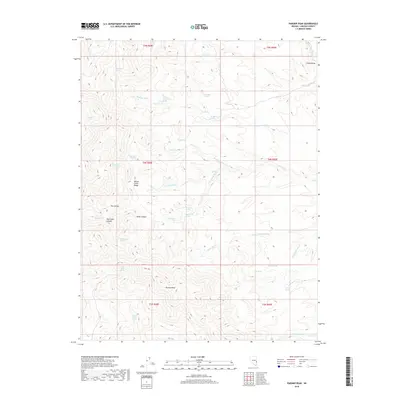
2018 Map of Parsnip Peak
USGS Topo · Published 2018About this map
Parsnip Peak serves as a dominant high point within the Wilson Creek Range, overseeing a landscape defined by an intricate network of desert water sources and canyons. The distribution of features like Frenchman Spring, Cold Spring, and Little Mud Springs suggests the critical importance of these reliable water points for livestock and land use in this high-desert environment. Deep incisions such as Tex Canyon and Hulse Canyon cut through the terrain, while seasonal drainages like Bowling Wash and Cole Spring Wash provide natural corridors through the ridges. This 2018 survey captures the area’s remote character, where place names often reflect early ranching and grazing history, seen in labels like Sage Hen Spring and Red Cedar Spring. The map also details the transition into Camp Valley at its northeastern edge, illustrating the topographic variety found within this corner of Lincoln County.
Find a feature on this map
43 named features on this map. Tap any name to fly to it.
Don’t see what you’re looking for? This feature index may not catch every label — zoom into the map to look around manually.
Map Details
Editions of this 2018 Parsnip Peak Map
This is the sole edition of this map. No revisions or reprints were ever made.
Other maps of this area

1956 · Lund
USGS Topo · 1:250,000

1960 · Lund
USGS Topo · 1:250,000
1970 · Mt. Wilson SW
USGS Topo · 1:24,000
1970 · Mt. Wilson
USGS Topo · 1:24,000

1970 · Pierson Summit
USGS Topo · 1:24,000

1970 · Parsnip Peak
USGS Topo · 1:24,000

1972 · Buck Wash Well
USGS Topo · 1:24,000
1972 · Eagle Valley Reservoir
USGS Topo · 1:24,000

1972 · Miller Canyon
USGS Topo · 1:24,000

1973 · Schoolmarm Basin
USGS Topo · 1:24,000