
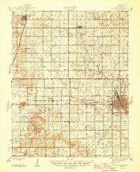
1947 Map of Parsons
USGS Topo · Published 1947About this map
Parsons serves as the industrial and social anchor of this Labette County landscape, where the Missouri Kansas and Texas and St Louis San Francisco and Texas railroads converge. The city's 1940s layout includes the extensive State Asylum grounds and specialized areas like Orchard Park. Beyond the urban center, the countryside is a dense network of rural school districts and family cemeteries, reflecting a period of high rural density. Features such as the Twin Mounds and Tacket Mound break the gentle terrain, while the Site of Wilsonton near the southern border suggests a settlement that had already faded by the time of this mid-century survey. Notable landmarks like the Water Works and Circle Park in the city, alongside dozens of rural schoolhouses like Sylvandale Sch and Catalpa Sch, provide an intimate look at the civic infrastructure of the era.
Find a feature on this map
87 named features on this map. Tap any name to fly to it.
Don’t see what you’re looking for? This feature index may not catch every label — zoom into the map to look around manually.
Map Details
Editions of this 1947 Parsons Map
2 editions found
Other maps of this area

1886 · Fredonia
USGS Topo · 1:125,000

1886 · Iola
USGS Topo · 1:125,000

1886 · Independence
USGS Topo · 1:125,000

1886 · Parsons
USGS Topo · 1:125,000

1893 · Iola
USGS Topo · 1:125,000

1893 · Parsons
USGS Topo · 1:125,000

1894 · Fredonia
USGS Topo · 1:125,000

1894 · Independence
USGS Topo · 1:125,000

1904 · Iola
USGS Topo · 1:125,000

1905 · Independence
USGS Topo · 1:125,000