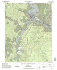
1995 Map of Parsons
USGS Topo · Published 1998About this map
Parsons sits at the vital confluence where the Shavers Fork and Black Fork unite to form the Cheat River, a geographic hub for the timber and mountain communities of Tucker County. This mid-1990s survey illustrates the complex drainage network of the Allegheny Mountains, including Clover Run and Dry Fork. The landscape is defined by the extensive reaches of the Monongahela National Forest, within which the Fernow Experimental Forest and the Otter Creek Wilderness preserve large tracts of high-elevation woodland. Small family-named cemeteries such as Goff Cem and Hamrick Cem are tucked along the hillsides and riverbanks, marking the deep ancestral ties of the area's residents. Further downstream, the settlements of Hambleton and Hendricks follow the narrow valley floors, while Backbone Mtn provides a significant topographic barrier to the east, illustrating the physical constraints that shaped early mountain settlement and transport.
Find a feature on this map
72 named features on this map. Tap any name to fly to it.
Don’t see what you’re looking for? This feature index may not catch every label — zoom into the map to look around manually.
Map Details
Editions of this 1995 Parsons Map
2 editions found
Other maps of this area

1886 · St. George
USGS Topo · 1:125,000

1889 · Beverly
USGS Topo · 1:125,000

1891 · St. George
USGS Topo · 1:125,000

1892 · Beverly
USGS Topo · 1:125,000

1907 · Belington
USGS Topo · 1:62,500

1908 · Parsons
USGS Topo · 1:62,500

1909 · Elkins
USGS Topo · 1:62,500

1922 · Horton
USGS Topo · 1:48,000

1924 · Horton
USGS Topo · 1:62,500

1926 · Parsons
USGS Topo · 1:62,500