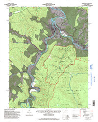
1995 Map of Parsons
USGS Topo · Published 1998About this map
The Parsons community and surrounding river valleys define this 1995 revision of a mid-century survey, where the confluence of the Black Fork and Shavers Fork forms the Cheat River. This landscape is heavily shaped by the sprawling Monongahela National Forest and specialized research areas like the Fernow Experimental Forest. Smaller settlements such as Bretz, Hambleton, and Hendricks cling to the riverbanks, reflecting a mountain economy tied to the water and forest resources. Local heritage is preserved in family-named cemeteries such as Goff Cem, Collett Cem, and Hamrick Cem, while rural spiritual life is centered around Irons Chapel and Farmers Chapel. The southeastern portion is dominated by the wilder reaches of the Otter Creek Wilderness and Mcgowan Mountain, where trails replace roads as the primary means of navigation through the steep terrain.
Find a feature on this map
88 named features on this map. Tap any name to fly to it.
Don’t see what you’re looking for? This feature index may not catch every label — zoom into the map to look around manually.
Map Details
Editions of this 1995 Parsons Map
2 editions found
Other maps of this area

1886 · St. George
USGS Topo · 1:125,000

1889 · Beverly
USGS Topo · 1:125,000

1891 · St. George
USGS Topo · 1:125,000

1892 · Beverly
USGS Topo · 1:125,000

1907 · Belington
USGS Topo · 1:62,500

1908 · Parsons
USGS Topo · 1:62,500

1909 · Elkins
USGS Topo · 1:62,500

1922 · Horton
USGS Topo · 1:48,000

1924 · Horton
USGS Topo · 1:62,500

1926 · Parsons
USGS Topo · 1:62,500