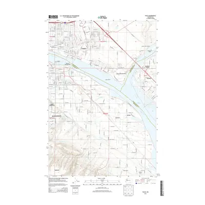
2014 Map of Pasco
USGS Topo · Published 2014About this map
The Columbia River and Snake River converge in this 2014 study of the Tri-Cities region, revealing a landscape deeply defined by water management and transportation. The meeting of these major waterways is marked by several landforms, including Clover Island, Strawberry Island, and Indian Island. The agricultural and industrial character of the area is evidenced by the complex irrigation network, featuring Columbia Canal Number 1, Columbia Canal Number 2, and Division Four Canal.
Find a feature on this map
188 named features on this map. Tap any name to fly to it.
Don’t see what you’re looking for? This feature index may not catch every label — zoom into the map to look around manually.
Map Details
Editions of this 2014 Pasco Map
This is the sole edition of this map. No revisions or reprints were ever made.
Other maps of this area

1915 · Wallulah
USGS Topo · 1:96,000

1917 · Pasco
USGS Topo · 1:125,000

1918 · Wallula
USGS Topo · 1:125,000

1953 · Walla Walla
USGS Topo · 1:250,000

1958 · Walla Walla
USGS Topo · 1:250,000

1964 · Wallula
USGS Topo · 1:24,000

1964 · Levey SW
USGS Topo · 1:24,000

1964 · Humorist
USGS Topo · 1:24,000
1964 · Johnson Butte
USGS Topo · 1:24,000
1964 · Nine Canyon
USGS Topo · 1:24,000