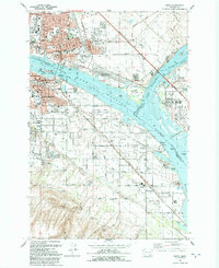
1992 Map of Pasco
USGS Topo · Published 1992About this map
Lake Wallula dominates the center of this 1990s-era map, where the Columbia River and Snake River converge. The industrial and transportation identity of the Tri-Cities is evident in the extensive rail lines of the Burlington Northern and Union Pacific, which serve the Port of Pasco Industrial Park and waterfront facilities like the Port of Kennewick. This map documents a developed landscape of established neighborhoods and civic institutions, featuring Lourdes Hospital, the County Fairgrounds, and numerous schools such as Stevens Jr High Sch and Columbia High Sch. Beyond the urban centers of Pasco and Kennewick, the landscape transitions to the agricultural and utility-focused outskirts of Finley and Hedges, where a network of aqueducts, flumes, and pumping stations supports the region's land use. The ecological importance of the river system is preserved at Sacajawea State Park and the McNary National Wildlife Refuge.
Find a feature on this map
92 named features on this map. Tap any name to fly to it.
Don’t see what you’re looking for? This feature index may not catch every label — zoom into the map to look around manually.
Map Details
Editions of this 1992 Pasco Map
This is the sole edition of this map. No revisions or reprints were ever made.
Other maps of this area

1915 · Wallulah
USGS Topo · 1:96,000

1917 · Pasco
USGS Topo · 1:125,000

1918 · Wallula
USGS Topo · 1:125,000

1953 · Walla Walla
USGS Topo · 1:250,000

1958 · Walla Walla
USGS Topo · 1:250,000

1964 · Wallula
USGS Topo · 1:24,000

1964 · Levey SW
USGS Topo · 1:24,000

1964 · Humorist
USGS Topo · 1:24,000
1964 · Johnson Butte
USGS Topo · 1:24,000
1964 · Nine Canyon
USGS Topo · 1:24,000