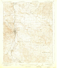
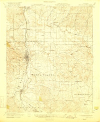
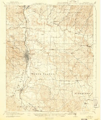
1919 Map of Paso Robles
USGS Topo · Published 1931About this map
San Miguel Mission stands as a primary landmark in this inland California landscape, marking the northern reach of a corridor defined by the Salinas River and the Southern Pacific Railroad. The map reveals an early 20th-century settlement pattern of small agricultural centers and rural schoolhouses positioned along the river valley and its eastern tributaries. While Paso Robles serves as the central hub, smaller points like Wellsona, Templeton, and Atascadero trace the rail line's path through the valley. East of the river, the terrain rises into the Santa Ysabel and Huerhuero regions, where a network of schools such as Estrella School, Dry Creek School, and Linne School serviced a dispersed ranching community. The concentration of these school sites and the established Parkfield Road and Bakersfield Road suggest a maturing rural infrastructure before the widespread modernization of the mid-century.
Find a feature on this map
56 named features on this map. Tap any name to fly to it.
Don’t see what you’re looking for? This feature index may not catch every label — zoom into the map to look around manually.
Map Details
Editions of this 1919 Paso Robles Map
5 editions found

Other maps of this area

1897 · San Luis Obispo
USGS Topo · 1:62,500

1897 · Cayucos
USGS Topo · 1:62,500

1900 · San Luis
USGS Topo · 1:125,000

1914 · Cholame
USGS Topo · 1:125,000

1915 · Cholame
USGS Topo · 1:125,000

1917 · Cholame
USGS Topo · 1:125,000

1919 · San Miguel
USGS Topo · 1:62,500

1919 · Paso Robles
USGS Topo · 1:62,500

1919 · Bradley
USGS Topo · 1:62,500

1919 · Adelaida
USGS Topo · 1:62,500