
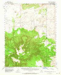
1953 Map of Pastora Peak
USGS Topo · Published 1956About this map
The Carrizo Mountains dominate this high-desert landscape within the Navajo Indian Reservation, rising sharply toward Pastora Pk and Zilbetod Peak. In the lower elevations, the settlement of Teec Nos Pos serves as a focal point for the region, featuring the Carrizo Mission Sch and a local Trading Post. To the east, near the Arizona and New Mexico border, the small community of Bitlabito sits alongside Bitlabito Wash, accompanied by the Foutz Trading Post. The map reveals a land defined by its drainage systems, where Tsitah Wash and Tadastoni Wash carve through the northern plains below Cow Butte. These seasonal watercourses and landforms like Toh-Chin-Lini Mesa reflect the geographic isolation and specialized infrastructure of the Four Corners region during the mid-1950s.
Find a feature on this map
36 named features on this map. Tap any name to fly to it.
Don’t see what you’re looking for? This feature index may not catch every label — zoom into the map to look around manually.
Map Details
Editions of this 1953 Pastora Peak Map
2 editions found
Other maps of this area

1886 · Abajo
USGS Topo · 1:250,000

1889 · Chaco
USGS Topo · 1:250,000

1892 · Abajo
USGS Topo · 1:250,000

1892 · Chaco
USGS Topo · 1:250,000

1892 · Canyon De Chelly
USGS Topo · 1:250,000

1893 · Abajo
USGS Topo · 1:250,000

1934 · Ship Rock
USGS Topo · 1:62,500

1934 · Rattlesnake
USGS Topo · 1:62,500

1937 · Ship Rock
USGS Topo · 1:62,500

1937 · Rattlesnake
USGS Topo · 1:62,500