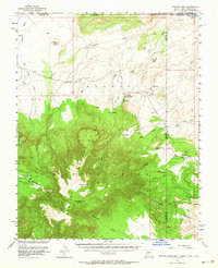
1953 Map of Pastora Peak
USGS Topo · Published 1964About this map
The Carrizo Mountains dominate this high-desert landscape of the Navajo Indian Reservation, where the borders of Arizona, New Mexico, Utah, and Colorado converge. During this mid-century period, the settlement of Teec Nos Pas serves as a local hub, featuring a Trading Post, a Landing Strip, and the Carrizo Mission Sch. The terrain is defined by deep drainages like Toh Chin Lini Canyon and elevated landmarks such as Pastora Pk and Zlibetod Peak. The map documents a sparsely populated region reliant on water sources like Twin Falls and the San Juan River at the northern edge. Evidence of activity in the backcountry appears through labels for a prospect and the remote settlement of Bitlabito near the state line, illustrating the intersection of traditional land use and early infrastructure.
Find a feature on this map
30 named features on this map. Tap any name to fly to it.
Don’t see what you’re looking for? This feature index may not catch every label — zoom into the map to look around manually.
Map Details
Editions of this 1953 Pastora Peak Map
2 editions found

Other maps of this area

1886 · Abajo
USGS Topo · 1:250,000

1889 · Chaco
USGS Topo · 1:250,000

1892 · Abajo
USGS Topo · 1:250,000

1892 · Chaco
USGS Topo · 1:250,000

1892 · Canyon De Chelly
USGS Topo · 1:250,000

1893 · Abajo
USGS Topo · 1:250,000

1934 · Ship Rock
USGS Topo · 1:62,500

1934 · Rattlesnake
USGS Topo · 1:62,500

1937 · Ship Rock
USGS Topo · 1:62,500

1937 · Rattlesnake
USGS Topo · 1:62,500
Featured Places
- Shiprock Agency
- Beclabito, Shiprock Agency
- Beclabito, Shiprock Agency
- Twin Falls, Shiprock Agency
- Teec Nos Pos, Shiprock Agency