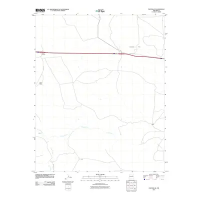
2010 Map of Pastura NE
USGS Topo · Published 2010About this map
Pintada Arroyo winds through the high plains of Guadalupe County, defining the drainage patterns of this arid landscape south of the modern interstate corridor. At the time of this 2010 survey, the region maintained a sparse, ranch-based settlement pattern characterized by wide-reaching pastures and localized family-named sites. The northern portion of the map is dominated by the transit infrastructure of the San Ignacio Interchange and the settlement of Colinas, where the I 40 Frontage RD parallels the primary highway. Further south, the landscape is dotted with utilitarian landmarks essential for life in the high desert, such as the Middle Pasture Windmill. The presence of small settlements like Martinez and Baca near the arroyo system suggests a historical reliance on these ephemeral watercourses, while Moise Ranch illustrates the large-scale landholdings typical of eastern New Mexico's ranching economy.
Find a feature on this map
12 named features on this map. Tap any name to fly to it.
Don’t see what you’re looking for? This feature index may not catch every label — zoom into the map to look around manually.
Map Details
Editions of this 2010 Pastura NE Map
This is the sole edition of this map. No revisions or reprints were ever made.
Other maps of this area

1892 · Corazon
USGS Topo · 1:125,000

1894 · Corazon
USGS Topo · 1:125,000

1954 · Santa Fe
USGS Topo · 1:250,000

1954 · Fort Sumner
USGS Topo · 1:250,000

1958 · Fort Sumner
USGS Topo · 1:250,000

1958 · Santa Fe
USGS Topo · 1:250,000

1963 · Colonias
USGS Topo · 1:24,000

1963 · Santa Rosa
USGS Topo · 1:24,000

1963 · Puerto Creek
USGS Topo · 1:24,000
1963 · Catfish Falls
USGS Topo · 1:24,000