
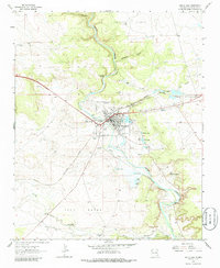
1963 Map of Santa Rosa
USGS Topo · Published 1965About this map
The Pecos River carves through this high desert landscape, serving as the lifeblood for both natural phenomena and local agriculture in the early 1960s. The town of Santa Rosa is the focal point, where the Southern Pacific railroad corridor intersects with local landmarks like the Fish Hatchery and the iconic Blue Hole. The map reveals a complex irrigation system essential to the region's ranching economy, featuring the Puerto de Luna Ditch, Ortega Ditch, and Casaus Ditch winding along the riverbanks.
Find a feature on this map
48 named features on this map. Tap any name to fly to it.
Don’t see what you’re looking for? This feature index may not catch every label — zoom into the map to look around manually.
Map Details
Editions of this 1963 Santa Rosa Map
2 editions found
Other maps of this area

1892 · Corazon
USGS Topo · 1:125,000

1894 · Corazon
USGS Topo · 1:125,000

1954 · Santa Fe
USGS Topo · 1:250,000

1954 · Fort Sumner
USGS Topo · 1:250,000

1958 · Fort Sumner
USGS Topo · 1:250,000

1958 · Santa Fe
USGS Topo · 1:250,000

1963 · Colonias
USGS Topo · 1:24,000

1963 · Puerto Creek
USGS Topo · 1:24,000

1963 · Sunshine Mesa
USGS Topo · 1:24,000

1963 · Puerto De Luna
USGS Topo · 1:24,000