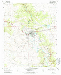
1963 Map of Santa Rosa
USGS Topo · Published 1986About this map
Santa Rosa thrives at the convergence of vital rail lines and desert water sources in the early 1960s. The Chicago Rock Island and Pacific and Southern Pacific railroads dominate the local geography, intersecting near the town center. The hydrological landscape is remarkably diverse for the high plains, featuring the Pecos River and a series of natural sinkhole lakes including Blue Hole, Perch Lake, and Rock Lake. These water features supported both recreation and industry, evidenced by the Fish Hatchery and numerous irrigation channels like Casaus Ditch and the West Puerto de Luna Ditch. Local history is anchored by several burial grounds, including St Rose of Lima Cem and Evergreen Cemetery, while landmarks like the Drive-in Theater and Santa Rosa Landing Field reflect the mid-century transition of the region.
Find a feature on this map
50 named features on this map. Tap any name to fly to it.
Don’t see what you’re looking for? This feature index may not catch every label — zoom into the map to look around manually.
Map Details
Editions of this 1963 Santa Rosa Map
2 editions found
Other maps of this area

1892 · Corazon
USGS Topo · 1:125,000

1894 · Corazon
USGS Topo · 1:125,000

1954 · Santa Fe
USGS Topo · 1:250,000

1954 · Fort Sumner
USGS Topo · 1:250,000

1958 · Fort Sumner
USGS Topo · 1:250,000

1958 · Santa Fe
USGS Topo · 1:250,000

1963 · Colonias
USGS Topo · 1:24,000

1963 · Santa Rosa
USGS Topo · 1:24,000

1963 · Puerto Creek
USGS Topo · 1:24,000

1963 · Sunshine Mesa
USGS Topo · 1:24,000