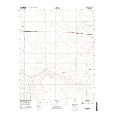
2013 Map of Pastura NE
USGS Topo · Published 2013About this map
Pintada Arroyo cuts a deep, winding path through this corner of Guadalupe County, defining the drainage patterns of the high plains landscape south of the San Ignacio Interchange. The map documentation highlights a pastoral and ranching economy, centered on named locales such as the Moise Ranch and several dispersed settlements including Colinas, Martinez, and Baca. This early 21st-century landscape is marked by essential water infrastructure for livestock, represented by the Middle Pasture Windmill. Transportation is dominated by the modern interstate corridor running through the northern section, while secondary routes like Co Road 4 provide access to the more isolated areas near Arroyo Hernandez and Arroyo El Ojito.
Find a feature on this map
19 named features on this map. Tap any name to fly to it.
Don’t see what you’re looking for? This feature index may not catch every label — zoom into the map to look around manually.
Map Details
Editions of this 2013 Pastura NE Map
This is the sole edition of this map. No revisions or reprints were ever made.
Other maps of this area

1892 · Corazon
USGS Topo · 1:125,000

1894 · Corazon
USGS Topo · 1:125,000

1954 · Santa Fe
USGS Topo · 1:250,000

1954 · Fort Sumner
USGS Topo · 1:250,000

1958 · Fort Sumner
USGS Topo · 1:250,000

1958 · Santa Fe
USGS Topo · 1:250,000

1963 · Colonias
USGS Topo · 1:24,000

1963 · Santa Rosa
USGS Topo · 1:24,000

1963 · Puerto Creek
USGS Topo · 1:24,000
1963 · Catfish Falls
USGS Topo · 1:24,000