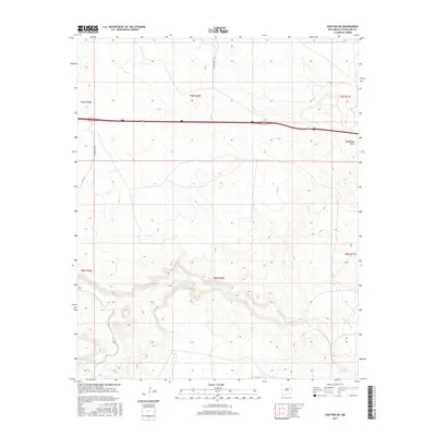
2017 Map of Pastura NE
USGS Topo · Published 2017About this map
Pintada Arroyo carves a deep, winding path through this portion of Guadalupe County, defining the drainage patterns of an arid New Mexico landscape. The topography here is characterized by the complex contours surrounding Guadalupe Draw and the various arroyos that feed into the larger basin. Transportation across this rural expanse is dominated by the corridor of Interstate 40 and US Highway 84, which cut a straight line across the northern section. Away from the highway, a network of local thoroughfares including Colonias Rd, Margarito Rd, and Co Rd 4 B provide access to the vast ranchlands. The map reveals the intricate land management boundaries of the Township and Range system, specifically covering parts of t9n r20e and its neighbors, showing how the territory is segmented between the highway and the natural watercourses.
Find a feature on this map
13 named features on this map. Tap any name to fly to it.
Don’t see what you’re looking for? This feature index may not catch every label — zoom into the map to look around manually.
Map Details
Editions of this 2017 Pastura NE Map
This is the sole edition of this map. No revisions or reprints were ever made.
Other maps of this area

1892 · Corazon
USGS Topo · 1:125,000

1894 · Corazon
USGS Topo · 1:125,000

1954 · Santa Fe
USGS Topo · 1:250,000

1954 · Fort Sumner
USGS Topo · 1:250,000

1958 · Fort Sumner
USGS Topo · 1:250,000

1958 · Santa Fe
USGS Topo · 1:250,000

1963 · Colonias
USGS Topo · 1:24,000

1963 · Santa Rosa
USGS Topo · 1:24,000

1963 · Puerto Creek
USGS Topo · 1:24,000
1963 · Catfish Falls
USGS Topo · 1:24,000