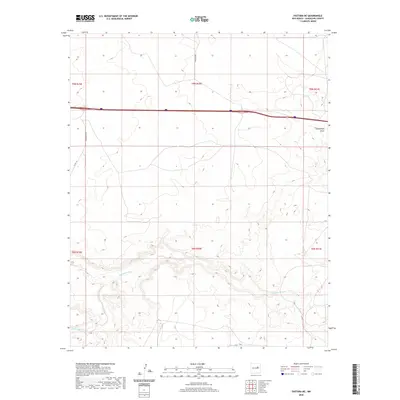
2020 Map of Pastura NE
USGS Topo · Published 2020About this map
Pintada Arroyo meanders through this portion of Guadalupe County, defining the drainage patterns of a landscape marked by intermittent watercourses. In this high plains environment, the presence of features like Arroyo Hernandez and Arroyo El Ojito indicates the critical role of seasonal water in shaping both the terrain and the ranching history of the area. Connectivity across this rural expanse is maintained by a sparse network of local thoroughfares, including Colonias Rd and Margarito Rd, which provide access between the scattered draws such as Guadalupe Draw. The map illustrates the traditional Public Land Survey System divisions, with numerous township and range lines reflecting the orderly distribution of land in this part of New Mexico.
Find a feature on this map
13 named features on this map. Tap any name to fly to it.
Don’t see what you’re looking for? This feature index may not catch every label — zoom into the map to look around manually.
Map Details
Editions of this 2020 Pastura NE Map
This is the sole edition of this map. No revisions or reprints were ever made.
Other maps of this area

1892 · Corazon
USGS Topo · 1:125,000

1894 · Corazon
USGS Topo · 1:125,000

1954 · Santa Fe
USGS Topo · 1:250,000

1954 · Fort Sumner
USGS Topo · 1:250,000

1958 · Fort Sumner
USGS Topo · 1:250,000

1958 · Santa Fe
USGS Topo · 1:250,000

1963 · Colonias
USGS Topo · 1:24,000

1963 · Santa Rosa
USGS Topo · 1:24,000

1963 · Puerto Creek
USGS Topo · 1:24,000
1963 · Catfish Falls
USGS Topo · 1:24,000