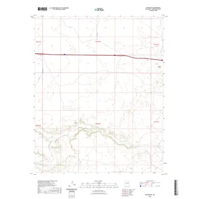
2023 Map of Pastura NE
USGS Topo · Published 2023About this map
Pintada Arroyo carves a deep, winding path across this portion of Guadalupe County, serving as the primary drainage feature in a landscape defined by its seasonal watercourses. The map captures the complex hydrology of the High Plains, where smaller tributaries like Arroyo Hernandez and Arroyo El Ojito feed into the larger system. The terrain is further marked by Guadalupe Draw in the northeastern corner, illustrating the natural erosion patterns of the region.
Find a feature on this map
14 named features on this map. Tap any name to fly to it.
Don’t see what you’re looking for? This feature index may not catch every label — zoom into the map to look around manually.
Map Details
Editions of this 2023 Pastura NE Map
This is the sole edition of this map. No revisions or reprints were ever made.
Other maps of this area

1892 · Corazon
USGS Topo · 1:125,000

1894 · Corazon
USGS Topo · 1:125,000

1954 · Santa Fe
USGS Topo · 1:250,000

1954 · Fort Sumner
USGS Topo · 1:250,000

1958 · Fort Sumner
USGS Topo · 1:250,000

1958 · Santa Fe
USGS Topo · 1:250,000

1963 · Colonias
USGS Topo · 1:24,000

1963 · Santa Rosa
USGS Topo · 1:24,000

1963 · Puerto Creek
USGS Topo · 1:24,000
1963 · Catfish Falls
USGS Topo · 1:24,000