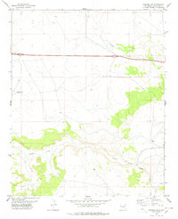
1978 Map of Pastura NE
USGS Topo · Published 1978About this map
Pintada Arroyo and Guadalupe Draw carve through this landscape of Guadalupe County, defining the drainage patterns of the high plains in the late 1970s. The map illustrates a sparse ranching environment where water sources like the Middle Pasture Windmill, an unnamed Water Tank, and the spring at Ojito are critical landmarks for local navigation and land use. Settlement is limited to isolated holdings such as the Moise Ranch, which sits near the southern bend of the arroyo. Transportation infrastructure is dominated by the Southern Pacific railroad corridor and the east-west alignment of Interstate 40, providing a stark contrast between the modern highway system and the rugged drainage of Arroyo Hernandez.
Find a feature on this map
16 named features on this map. Tap any name to fly to it.
Don’t see what you’re looking for? This feature index may not catch every label — zoom into the map to look around manually.
Map Details
Editions of this 1978 Pastura NE Map
This is the sole edition of this map. No revisions or reprints were ever made.
Other maps of this area

1892 · Corazon
USGS Topo · 1:125,000

1894 · Corazon
USGS Topo · 1:125,000

1954 · Santa Fe
USGS Topo · 1:250,000

1954 · Fort Sumner
USGS Topo · 1:250,000

1958 · Fort Sumner
USGS Topo · 1:250,000

1958 · Santa Fe
USGS Topo · 1:250,000

1963 · Colonias
USGS Topo · 1:24,000

1963 · Santa Rosa
USGS Topo · 1:24,000

1963 · Puerto Creek
USGS Topo · 1:24,000
1963 · Catfish Falls
USGS Topo · 1:24,000