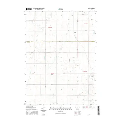
2015 Map of Paton
USGS Topo · Published 2015About this map
Paton stands as the primary community in this section of the Iowa plains, situated at the boundary of Greene and Webster counties. The landscape is defined by the headwaters and intricate drainages of several waterways, including W Buttrick Cr, Lost Br, and the Devils Fork. These streams cut through a highly structured section-line road grid, where large-scale agriculture is the dominant feature. The small settlement of Lena and the Dawson Cem provide focal points for local history and genealogy, marking the placement of earlier rural hubs. Significant county thoroughfares like Co Hwy E18 and Co Hwy P33 bisect the townships, facilitating the movement of goods and people across this fertile prairie region. The layout of S Main St and S Park St within the town site reveals the planned growth of the local municipal center.
Find a feature on this map
42 named features on this map. Tap any name to fly to it.
Don’t see what you’re looking for? This feature index may not catch every label — zoom into the map to look around manually.
Map Details
Editions of this 2015 Paton Map
This is the sole edition of this map. No revisions or reprints were ever made.
Other maps of this area

1923 · Lehigh
USGS Topo · 1:62,500

1951 · Ogden
USGS Topo · 1:62,500

1954 · Fort Dodge
USGS Topo · 1:250,000

1957 · Fort Dodge
USGS Topo · 1:250,000

1958 · Fort Dodge
USGS Topo · 1:250,000

1962 · Jefferson
USGS Topo · 1:62,500

1965 · Farnhamville
USGS Topo · 1:24,000

1965 · Gowrie
USGS Topo · 1:24,000

1965 · Harcourt
USGS Topo · 1:24,000
1982 · Lanyon
USGS Topo · 1:24,000