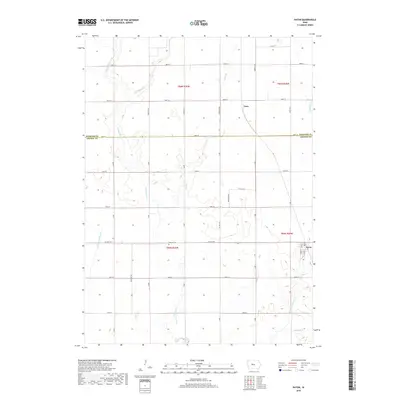
2018 Map of Paton
USGS Topo · Published 2018About this map
Paton anchors the southeastern corner of this Central Iowa landscape, where the grid of Greene and Webster counties meets an intricate drainage system of prairie creeks. This 2018 survey documents the agricultural heartland as it transitions between Webster and Greene counties along 100th St and 400th St. The terrain is defined by the winding paths of W Buttrick Cr and Lost Br, which break the geometric precision of the section lines and rural road network. Near the center of the sheet, the Dawson Cem sits along Co Hwy E18, serving as a localized point of historical reference for the surrounding farming community. To the north, the small settlement of Lena is positioned along the rail corridor, illustrating the traditional relationship between rural hamlets and transportation lines in the region.
Find a feature on this map
42 named features on this map. Tap any name to fly to it.
Don’t see what you’re looking for? This feature index may not catch every label — zoom into the map to look around manually.
Map Details
Editions of this 2018 Paton Map
This is the sole edition of this map. No revisions or reprints were ever made.
Other maps of this area

1923 · Lehigh
USGS Topo · 1:62,500

1951 · Ogden
USGS Topo · 1:62,500

1954 · Fort Dodge
USGS Topo · 1:250,000

1957 · Fort Dodge
USGS Topo · 1:250,000

1958 · Fort Dodge
USGS Topo · 1:250,000

1962 · Jefferson
USGS Topo · 1:62,500

1965 · Farnhamville
USGS Topo · 1:24,000

1965 · Gowrie
USGS Topo · 1:24,000

1965 · Harcourt
USGS Topo · 1:24,000
1982 · Lanyon
USGS Topo · 1:24,000