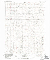
1986 Map of Paton
USGS Topo · Published 1986About this map
Paton anchors this rural landscape at the edge of the Webster Co Greene Co line, serving as a hub for the surrounding agricultural community. The terrain is defined by the winding paths of West Buttrick Creek and East Buttrick Creek, which converge to the south after passing through the townships of Gowrie and Lost Grove. The Chicago and North Western railroad cuts diagonally through the northeast, passing the small settlement of Lena. Local history is preserved at the Dawson Cem, located near the central drainage of Lost Branch. The presence of the Pemble Landing Strip and the grid-patterned fields reflect a mid-century Iowa economy where traditional rail transport and modern aviation supported a landscape of extensive prairie farming.
Find a feature on this map
18 named features on this map. Tap any name to fly to it.
Don’t see what you’re looking for? This feature index may not catch every label — zoom into the map to look around manually.
Map Details
Editions of this 1986 Paton Map
This is the sole edition of this map. No revisions or reprints were ever made.
Other maps of this area

1923 · Lehigh
USGS Topo · 1:62,500

1951 · Ogden
USGS Topo · 1:62,500

1954 · Fort Dodge
USGS Topo · 1:250,000

1957 · Fort Dodge
USGS Topo · 1:250,000

1958 · Fort Dodge
USGS Topo · 1:250,000

1962 · Jefferson
USGS Topo · 1:62,500

1965 · Farnhamville
USGS Topo · 1:24,000

1965 · Gowrie
USGS Topo · 1:24,000

1965 · Harcourt
USGS Topo · 1:24,000
1982 · Lanyon
USGS Topo · 1:24,000