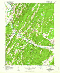
1949 Map of Patterson Creek
USGS Topo · Published 1963About this map
The North Branch Potomac River serves as the primary artery through this 1949 landscape, carving a route through the parallel ridges of the Appalachian range on the border of Maryland and West Virginia. This era shows the dominance of mid-century rail and water infrastructure, where the Baltimore and Ohio RR and Western Maryland RR shadow the winding riverbanks. A significant historical marker is the Chesapeake and Ohio Canal (Abandoned), which remains visible as a defunct but prominent feature of the corridor. Small settlements like North Branch, Spring Gap, and Green Spring anchor the rural valley, supported by local institutions such as St Marys Cem and Bethel Tabernacle. The terrain is characterized by steep ridges including Collier Mountain and Warrior Mountain, punctuated by numerous family-named hollows like Brite Hollow and Frog Hollow that suggest long-standing local genealogies.
Find a feature on this map
57 named features on this map. Tap any name to fly to it.
Don’t see what you’re looking for? This feature index may not catch every label — zoom into the map to look around manually.
Map Details
Editions of this 1949 Patterson Creek Map
3 editions found
Other maps of this area

1891 · Romney
USGS Topo · 1:125,000

1898 · Frostburg
USGS Topo · 1:62,500

1899 · Flintstone
USGS Topo · 1:62,500

1900 · Flintstone
USGS Topo · 1:62,500

1901 · Frostburg
USGS Topo · 1:62,500

1908 · Frostburg
USGS Topo · 1:62,500

1920 · Keyser
USGS Topo · 1:62,500

1921 · Keyser
USGS Topo · 1:48,000

1921 · Hanging Rock
USGS Topo · 1:48,000

1922 · Keyser
USGS Topo · 1:62,500