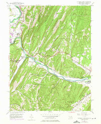
1949 Map of Patterson Creek
USGS Topo · Published 1975About this map
The North Branch Potomac River serves as the winding border between Maryland and West Virginia, dictating the early industrial and transit patterns of this region. By the mid-20th century, the landscape preserved the remnants of 19th-century infrastructure, most notably the Chesapeake and Ohio Canal (Abandoned) which runs parallel to the Baltimore and Ohio Railroad. These transport corridors carved paths through the formidable terrain of Warrior Mountain and Collier Mountain.
Find a feature on this map
58 named features on this map. Tap any name to fly to it.
Don’t see what you’re looking for? This feature index may not catch every label — zoom into the map to look around manually.
Map Details
Editions of this 1949 Patterson Creek Map
3 editions found
Other maps of this area

1891 · Romney
USGS Topo · 1:125,000

1898 · Frostburg
USGS Topo · 1:62,500

1899 · Flintstone
USGS Topo · 1:62,500

1900 · Flintstone
USGS Topo · 1:62,500

1901 · Frostburg
USGS Topo · 1:62,500

1908 · Frostburg
USGS Topo · 1:62,500

1920 · Keyser
USGS Topo · 1:62,500

1921 · Keyser
USGS Topo · 1:48,000

1921 · Hanging Rock
USGS Topo · 1:48,000

1922 · Keyser
USGS Topo · 1:62,500