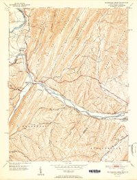
1951 Map of Pattersons Creek
USGS Topo · Published 1951About this map
The Potomac River carves through a landscape of ridges and hollows along the Maryland and West Virginia border, where early transportation infrastructure defined the valley's development. This mid-century survey illustrates a dense network of rail lines including the Baltimore and Ohio and the Western Maryland, running parallel to the Chesapeake and Ohio Canal (Abandoned). Small settlements like Pattersons Creek and Green Spring serve as anchors in the river bottomlands, while the surrounding heights of Collier Mountain and Warrior Mountain are dotted with rural landmarks. Genealogists will find a wealth of community centers, from Davis Church and Bethel Tabernacle to several family-named landmarks like St Marys Cem and Olivers Grove Ch. The map captures a moment when the industrial weight of the railroads still dictated the local economy, even as the old canal had already transitioned into a historical artifact of the previous century.
Find a feature on this map
51 named features on this map. Tap any name to fly to it.
Don’t see what you’re looking for? This feature index may not catch every label — zoom into the map to look around manually.
Map Details
Editions of this 1951 Pattersons Creek Map
2 editions found
Other maps of this area

1891 · Romney
USGS Topo · 1:125,000

1898 · Frostburg
USGS Topo · 1:62,500

1899 · Flintstone
USGS Topo · 1:62,500

1900 · Flintstone
USGS Topo · 1:62,500

1901 · Frostburg
USGS Topo · 1:62,500

1908 · Frostburg
USGS Topo · 1:62,500

1920 · Keyser
USGS Topo · 1:62,500

1921 · Keyser
USGS Topo · 1:48,000

1921 · Hanging Rock
USGS Topo · 1:48,000

1922 · Keyser
USGS Topo · 1:62,500