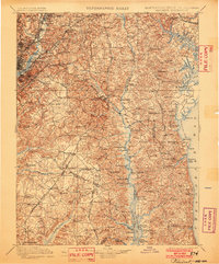
1899 Map of Patuxent
USGS Topo · Published 1902About this map
The Patuxent River corridor serves as the central artery for this late 19th-century landscape, illustrating a transition from river-based commerce to a rail-centered economy. Established river landings like Milltown Landing and Leitch Wharf along the lower Patuxent stand in contrast to the emerging rail hubs of Hyattsville and College Park in the northwest. The presence of the Maryland Agricl. College and the Piscataway Reform School highlights the early institutional development of Prince George's County. Settlement patterns follow the Baltimore & Potomac R.R. and the Pope Creek Branch, while older overland routes like the Marlboro Turnpike connect established towns such as Upper Marlboro. The topography reveals the intricate drainage basins of Zekiah Swamp and Mataponi Creek, reaching eastward to the shores of the Chesapeake Bay and Herring Bay.
Find a feature on this map
187 named features on this map. Tap any name to fly to it.
Don’t see what you’re looking for? This feature index may not catch every label — zoom into the map to look around manually.
Map Details
Editions of this 1899 Patuxent Map
3 editions found

Other maps of this area

1889 · Fredericksburg
USGS Topo · 1:125,000

1890 · Mt. Vernon
USGS Topo · 1:125,000

1891 · Mt. Vernon
USGS Topo · 1:125,000

1892 · Leonardtown
USGS Topo · 1:62,500

1892 · Laurel
USGS Topo · 1:62,500

1892 · Fredericksburg
USGS Topo · 1:125,000

1892 · Drum Point
USGS Topo · 1:62,500

1892 · Prince Frederick
USGS Topo · 1:62,500

1892 · Brandywine
USGS Topo · 1:62,500

1892 · Owensville
USGS Topo · 1:62,500