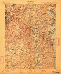
1906 Map of Patuxent
USGS Topo · Published 1912About this map
Maryland Agril. College stands at the northwestern edge of this landscape, anchoring a region defined by its complex drainage into the Chesapeake Bay. The terrain is shaped by the winding course of the Patuxent River, which forms the core of a rural network connecting the Prince Georges and Charles County line. Early transportation corridors like the Philadelphia and Washington RR and the Marlboro Turnpike reflect the era's movement between the burgeoning settlements of Hyattsville and Bladensburg.
Find a feature on this map
231 named features on this map. Tap any name to fly to it.
Don’t see what you’re looking for? This feature index may not catch every label — zoom into the map to look around manually.
Map Details
Editions of this 1906 Patuxent Map
4 editions found

Other maps of this area

1889 · Fredericksburg
USGS Topo · 1:125,000

1890 · Mt. Vernon
USGS Topo · 1:125,000

1891 · Mt. Vernon
USGS Topo · 1:125,000

1892 · Leonardtown
USGS Topo · 1:62,500

1892 · Laurel
USGS Topo · 1:62,500

1892 · Fredericksburg
USGS Topo · 1:125,000

1892 · Drum Point
USGS Topo · 1:62,500

1892 · Prince Frederick
USGS Topo · 1:62,500

1892 · Brandywine
USGS Topo · 1:62,500

1892 · Owensville
USGS Topo · 1:62,500