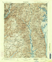
1906 Map of Patuxent
USGS Topo · Published 1934About this map
The Patuxent River bisects this landscape, serving as a primary corridor for commerce and travel between Prince George's, Anne Arundel, and Calvert Counties. The river's significance is highlighted by numerous landing sites and crossings like Magruder Ferry and Leitch Wharf, which provided vital connections for local agriculture before modern bridges dominated the region. To the west, the expansion of the capital is evident in the cluster of settlements including Hyattsville, Bladensburg, and the early grounds of the Maryland Agrl. College.
Find a feature on this map
149 named features on this map. Tap any name to fly to it.
Don’t see what you’re looking for? This feature index may not catch every label — zoom into the map to look around manually.
Map Details
Editions of this 1906 Patuxent Map
4 editions found

Other maps of this area

1889 · Fredericksburg
USGS Topo · 1:125,000

1890 · Mt. Vernon
USGS Topo · 1:125,000

1891 · Mt. Vernon
USGS Topo · 1:125,000

1892 · Leonardtown
USGS Topo · 1:62,500

1892 · Laurel
USGS Topo · 1:62,500

1892 · Fredericksburg
USGS Topo · 1:125,000

1892 · Drum Point
USGS Topo · 1:62,500

1892 · Prince Frederick
USGS Topo · 1:62,500

1892 · Brandywine
USGS Topo · 1:62,500

1892 · Owensville
USGS Topo · 1:62,500