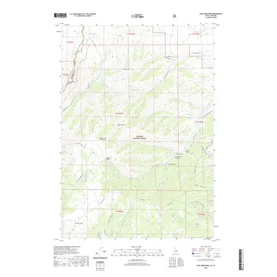
2020 Map of Paul Reservoir
USGS Topo · Published 2020About this map
The Beaverhead Mountains and the winding Continental Divide define this high-altitude landscape along the Montana-Idaho border. The 2020 terrain is dominated by the vast Targhee National Forest, where a complex network of drainages such as Modoc Cr and Stoddard Creek flow through deep ravines like Thunder Gulch and Brooks Canyon. Human infrastructure is sparse, characterized by high-country transit routes including the Continental Divide National Scenic Trail and the appropriately named Skyline Road. Water management in this arid environment is evidenced by the namesake Paul Reservoir, which collects runoff from the surrounding peaks. This survey captures a remote wilderness area where local geography is marked by descriptive landmarks like Lone Pine Spring, Swampy Draw, and the broad open space of Pleasant Valley.
Find a feature on this map
68 named features on this map. Tap any name to fly to it.
Don’t see what you’re looking for? This feature index may not catch every label — zoom into the map to look around manually.
Map Details
Editions of this 2020 Paul Reservoir Map
This is the sole edition of this map. No revisions or reprints were ever made.
Other maps of this area

1955 · Dubois
USGS Topo · 1:250,000

1957 · Paul Reservoir
USGS Topo · 1:62,500

1958 · Dubois
USGS Topo · 1:250,000

1968 · Corral Creek
USGS Topo · 1:24,000

1968 · Snowline
USGS Topo · 1:24,000

1968 · Monida
USGS Topo · 1:24,000

1972 · Spencer South
USGS Topo · 1:24,000

1972 · Spencer North
USGS Topo · 1:24,000

1983 · Dubois
USGS Topo · 1:100,000
1987 · Thunder Gulch
USGS Topo · 1:24,000