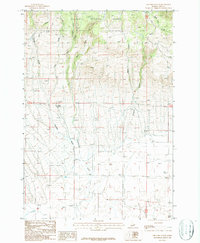
1987 Map of Thunder Gulch
USGS Topo · Published 1987About this map
The high country of Targhee National Forest dominates the northern reaches of this Idaho landscape, where a series of drainages descend from the timbered heights into the Clark County basin. Thunder Gulch and Cottonwood Creek cut through the central terrain, tracing the transition from forested ridges to the open, arid flats below. Evidence of early water management appears in the south with the Patzick Ditch, reflecting the necessity of irrigation for sustaining life and agriculture in this environment.
Find a feature on this map
14 named features on this map. Tap any name to fly to it.
Don’t see what you’re looking for? This feature index may not catch every label — zoom into the map to look around manually.
Map Details
Editions of this 1987 Thunder Gulch Map
This is the sole edition of this map. No revisions or reprints were ever made.
Other maps of this area

1955 · Dubois
USGS Topo · 1:250,000

1957 · Paul Reservoir
USGS Topo · 1:62,500

1958 · Dubois
USGS Topo · 1:250,000

1964 · Dubois NW
USGS Topo · 1:24,000

1964 · Lone Butte
USGS Topo · 1:24,000

1964 · Small
USGS Topo · 1:24,000

1972 · Spencer South
USGS Topo · 1:24,000

1972 · Spencer North
USGS Topo · 1:24,000

1983 · Dubois
USGS Topo · 1:100,000
1987 · Indian Creek
USGS Topo · 1:24,000