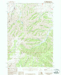
1987 Map of Paul Reservoir
USGS Topo · Published 1987About this map
The Continental Divide forms the primary topographical spine of this high-elevation landscape, where the borders of Beaverhead and Clark counties meet the state line between Montana and Idaho. This 1980s era survey detail is dominated by the sprawling reaches of the Targhee National Forest, a terrain defined by a complex network of canyons and drainage systems. Water management and resource use are central to the area's layout, evidenced by Paul Reservoir and various water sources like Lone Pine Spring.
Find a feature on this map
49 named features on this map. Tap any name to fly to it.
Don’t see what you’re looking for? This feature index may not catch every label — zoom into the map to look around manually.
Map Details
Editions of this 1987 Paul Reservoir Map
This is the sole edition of this map. No revisions or reprints were ever made.
Other maps of this area

1955 · Dubois
USGS Topo · 1:250,000

1957 · Paul Reservoir
USGS Topo · 1:62,500

1958 · Dubois
USGS Topo · 1:250,000

1968 · Corral Creek
USGS Topo · 1:24,000

1968 · Snowline
USGS Topo · 1:24,000

1968 · Monida
USGS Topo · 1:24,000

1972 · Spencer South
USGS Topo · 1:24,000

1972 · Spencer North
USGS Topo · 1:24,000

1983 · Dubois
USGS Topo · 1:100,000
1987 · Thunder Gulch
USGS Topo · 1:24,000